Trail Plane Peschiera Borromeo - Milan Paris - Photo
 jcm17
jcm17

User

© OpenStreetMap contributors
Length
Length
710 km
Max alt
Max alt
2969 m
Uphill gradient
Uphill gradient
38447 m
Km-Effort
Km-Effort  
1222 km
Min alt
Min alt
45 m
Downhill gradient
Downhill gradient
38455 m
Boucle
Boucle
No
Creation date :
2024-03-19 16:07:59.713
Updated on :
2024-03-23 14:09:37.786

(0 Reviews)

Plane
Plane
1h21
Difficulty : Very easy

Scan this QR Code to open this trail in the SityTrail application

FREE GPS app for hiking

Logo SityTrail SityTrail

IGN / Geographical institutes

Download SityTrail from the App Store Download SityTrail from Google Play

Logo SityTrail SityTrail World

The world is yours!

Download SityTrail from the App Store Download SityTrail from Google Play Download SityTrail on Huawei AppGallery

About

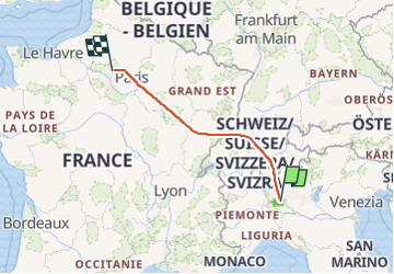
Trail Plane of 710 km to be discovered at Lombardy, Milan, Peschiera Borromeo. This trail is proposed by jcm17.

Elevation profile

Photos

Positioning

Country:
Italy
Region :
Lombardy
Department/Province :
Milan
Municipality :
Peschiera Borromeo
Location:
Unknown
Start:(UTM)
521878 ; 5032915 (32T) N.

Trails nearby

Trail Walking Milan - Susanna parking - Photo
Walking
Claude-Alain

Walking

Very easy
Milan, Lombardy, Milan, Italy
1.9 km | 2.1 km-effort
21min
No


Close
My subscriptions